

APPLICATIONS
Our unique land survey capabilities have proven to be a valuable resource across a wide range of applications. Able to remotely detect surface changes in mining operations, inspect infrastructure such as bridges and pipelines, or measure global peatland condition and carbon emissions, our technology offers solutions to meet our clients' needs.
Quick Links:


MINING
Our technology enables us to conduct comprehensive monitoring of ground movement, slope stability, surface expansion/compaction, and structural integrity across different types of mining operations, providing valuable information that can effectively guide operations and even provide warning of potential issues.
Opencast Mines
APSIS™ is able to detect minute changes in slope stability. This is crucial for assessing the stability of mine walls, preventing landslides, and detecting anomalous ground movements in the mine surrounds. APSIS™ measurements can also complement other geodetic monitoring techniques.

Tailings Storage Facilities
APSIS™ has been proven to be invaluable in the monitoring of the structural integrity of tailings storage facilities (TSF). Precursory deformations, greater than the levels associated with expected consolidation rates, have been measured at high-profile collapses such as those at Brumadinho and Cadia mines. Comprehensive monitoring with ubiquitous ground coverage of the entire TSF is only possible using APSIS™.

Underground Mines
APSIS™ is able to monitor surface subsidence associated with underground extraction from operations such as longwall mining and block caving. It can help detect ground deformation around mine entrances and shafts, providing early warning of potential structural issues to surface assets and infrastructure.

Dewatering
Changing groundwater levels from dewatering operations cause compaction or expansion at the surface due to changes in hydrostatic pressure. APSIS™ is able to monitor such changes and can be inverted to model changes in groundwater levels.


INFRASTRUCTURE
APSIS™ offers the capability to monitor linear infrastructure such as bridges, tunnels, roads, rail, and pipelines. Wide-area coverage enables comprehensive spatial and temporal monitoring without the need for extensive traditional surveys. This can be utilized to target ground-based surveys and manual inspections, making APSIS™ a highly cost-effective solution, particularly in remote areas with harsh climates.

Linear Infrastructure
InSAR can monitor the condition and stability of transport infrastructure such as roads, railways, bridges, pipelines, and underground tunnels. It is highly effective in monitoring hard-to-reach or hazardous locations and can identify deformations that could compromise structural integrity, lead to safety risks, or cause operational disruptions. Wide-area surveys are a cost-effective tool for proactive maintenance and can provide valuable insights without the need for physical inspections.

Oil and Gas
The monitoring of oil & gas infrastructure can be essential to ensure their safe operation, especially in regions prone to subsidence, seismic activity, or other geological risks. InSAR can detect millimetric deformations which can be used to calibrate geo-mechanical models, verify the amount of fluid injected/extracted, ensure caprock integrity, measure any leakage, and provide early warning of problems.

Geohazards
InSAR is a key tool for identifying and monitoring geohazards such as landslides, earthquakes, and ground deformation due to seismic activity. The early detection of ground movement can help to quantify areas at risk and enable proactive mitigation measures to be taken. Wide-area monitoring enables multi-hazard inventories to be kept up to date.

Dams and Embankments
Ensuring the stability of dams and embankments is vital for preventing catastrophic failures. InSAR is a cost-effective tool for regularly monitoring the deformation of dam structures and the surrounding terrain. Even small displacements can be early warning signs of structural failures.
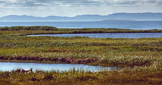
PEATLAND CONDITION ASSESSMENT
Terra Motion’s APSIS™ measurements have been demonstrated to be invaluable in assessing peatland and permafrost conditions and emissions flux. Our unique capabilities are helping to accelerate global investment in peatland restoration and have proven to be a precious commodity in the fight against climate change.
Peatlands serve as vital carbon sinks, playing a crucial role in mitigating climate change. Terra Motion has the ability to provide baselines of these areas, which can help determine current carbon/methane loss, as well as provide an indication of areas that can be restored, thereby avoiding future carbon loss. This can ultimately be leveraged for potential carbon offsets. We can monitor the condition and health of peatlands on an annual basis to monitor the success of peatland restoration activities after mining, drainage or fires. Terra Motion’s peatland monitoring capabilities offer the additional benefit of enabling assessments on biodiversity, water table depth, water quality, and wildfire risk.
Our intent is to support and enable the global investment community to drive significant and real progress toward a resilient and net-zero future. This will be achieved through innovative carbon monitoring, reporting & verification solutions and successful engagement with project developers, carbon registries, policymakers, and investors in peatland restoration.
Strategy
-
Monitoring & establishing the health/condition of peatland.
-
Monitoring restored peatland following mining & forest fires.
-
Establishing carbon credits protocol/process and MRV for peatland.
Peatland Condition and Emissions

APSIS™ InSAR can track changes in peat surface height which can be used to assess the condition of peatlands. Monitoring peat condition can provide quantitative data on greenhouse gas emissions which can be used to ensure that these areas remain as natural carbon sinks. In degraded or disturbed peatlands that have been subject to restoration, InSAR can even be used to assess the effectiveness of restoration activities and provide high-quality, auditable evidence for carbon credit programs.
Peatland Carbon Potential

Peatlands are important natural carbon sinks, storing vast amounts of carbon in their soil. Subsidence or shrinkage of the peat surface may indicate degradation, often linked to drainage, peat extraction, or environmental stress which can release stored carbon back into the atmosphere. Wide-area APSIS™ InSAR can be used to identify peatlands that are in the poorest condition. This can help target investment in peatland restoration activities to ensure the greatest outcomes in climate change mitigation.
DEFENCE
Due to radars systems all-weather, day and night capabilities, SAR imagery provides a wealth of information for security and defence applications. It affords a covert, cost-effective and wide-area solution for detecting hidden threats and supporting operation decision-making.
Underground Activities
APSIS™ InSAR is capable of inferring information about the presence of underground activities. Subtle ground movements often occur following underground material excavation. Underground activities of all scales have been observed, such as those which result from the construction of underground bunkers, smuggling tunnels, and larger underground engineering works. APSIS™ can be applied for broad area searches with no a priori knowledge of activities, or for site surveillance and ongoing monitoring of known targets.

Reconnaissance & Surveillance
SAR amplitude, coherence and polarimetry provide critical capabilities for reconnaissance and surveillance by enabling detection and classification of surface features and activities. Amplitude imagery delivers high-resolution data for identifying infrastructure, vehicles, and terrain changes. Coherence change detection detects surface disturbances, revealing human activities and construction. SAR polarimetry adds an extra layer of intelligence by distinguishing material types and structural properties. This improves the ability to identify military assets, hidden facilities, and objects concealed under vegetation.
